By Paul Basha, traffic engineer, Summit Land Management
What else can you tell us about travel during the pandemic?
United States travel data related to the Coronavirus Disease response is being compiled by the Maryland Transportation Institute in partnership with the Advanced Transportation Technology Laboratory, both associated with the University of Maryland. The citations for this research are:
- Maryland Transportation Institute (2020). University of Maryland COVID-19 Impact Analysis Platform, https://data.covid.umd.edu, University of Maryland, College Park, USA, accessed on 30 September 2020.
- Zhang L, Ghader S, Pack M, Darzi A, Xiong C, Yang M, Sun Q, Kabiri A, Hu S. (2020). An interactive COVID-19 mobility impact and social distancing analysis platform. medRxiv 2020. DOI: https://doi.org/10.1101/2020.04.29.20085472 (preprint).
The Maryland Transportation Institute states on their website that they calculated the average number of trips-per-person-per-day and the average number of miles-traveled-per-person-per-day. The daily miles traveled calculations consider all travel modes: car, train, bus, plane, bike, and walk. They do not explain how they determined the raw data, though presumably blue tooth technology was utilized. The magnitudes of the calculation results are reasonable. The value of the data are comparisons between different months and different counties.
The graphs below were developed by Summit Land Management from the data provided by Dr. Lei Zhang. Two presumably different counties were selected to compare to Maricopa County: very urban Los Angeles County in California and small-town Yavapai County in northern Arizona.
The consistency of travel characteristics in the three counties is striking. Goodness, human migration is habitual!
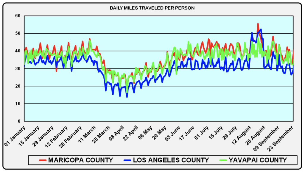
In all three counties, prior to the covid pandemic, people traveled between 30 and 45 miles-per-day, with Maricopa County at the high end of the range and Los Angeles County at the low end. For the ten weeks from late March to the end of May people in Maricopa and Yavapai counties traveled between 20 and 30 miles-per-day, while people in Los Angeles County traveled between
15 and 25 miles daily. For June through September, people again generally traveled between 30 and 45 miles daily – with a noticeable increase in August in all three counties.
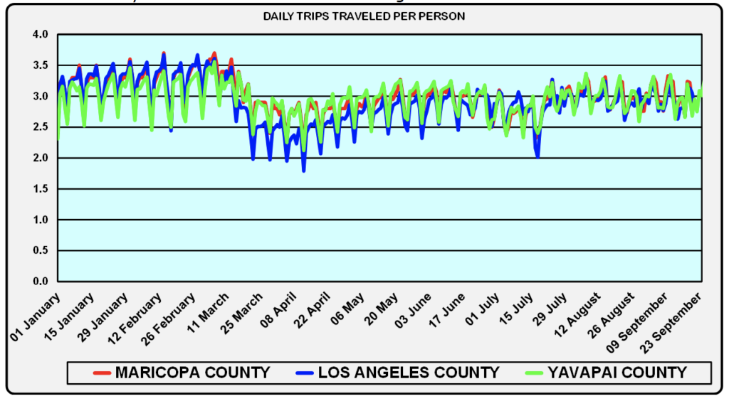
In all three counties, prior to the covid pandemic, people took 2.5 to 3.5 trips-per-day, with Los Angeles at the high end of the range. From late March through July, people took slightly fewer daily trips, between 2 and 3, though Los Angeles County was at the low end of the range. From the end of July through September, people took 3 trips-per-day, uniformly in all three counties.
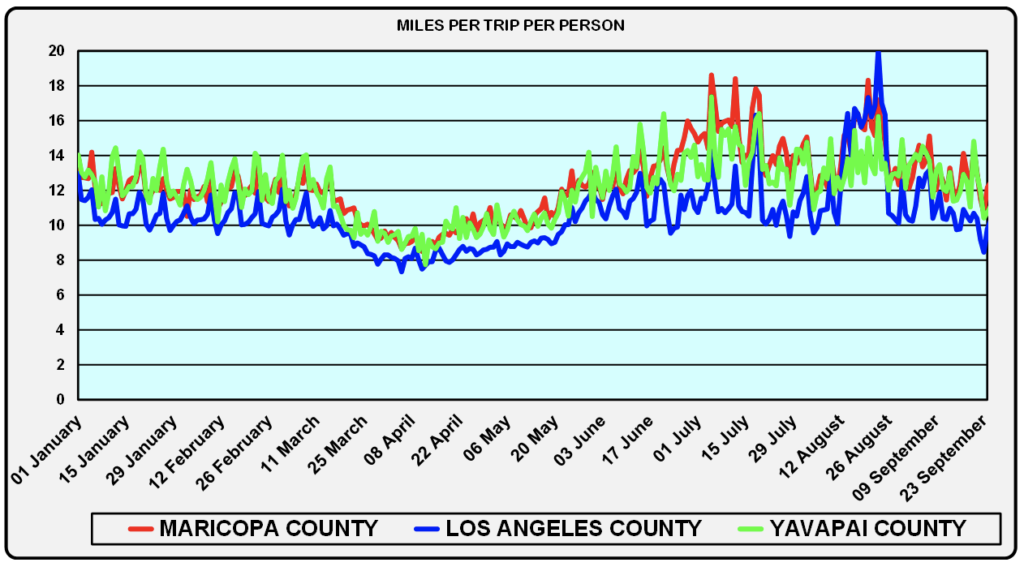
In Maricopa and Yavapai counties, from January through early March, people drove an average of 12 to 14 miles-per-trip, while in Los Angeles County people drove 10 to 12 miles-per-trip. From March through June, people reduced their trip lengths in all three counties. Trip lengths increased in June with the longest in Yavapai County and the shortest in Los Angeles County. In early July, people in all three counties took longer trips, with Maricopa County residents taking the longest trips. In August, Maricopa and Los Angeles county residents took longer trips than in July and September. In September, trip lengths in all three counties returned to pre-covid lengths.
Incidentally, the regular peak highs are Fridays, and the regular peak lows are Mondays. Yes, social science exists in traffic patterns.
Intriguing that in sprawling Los Angeles County travel behavior is approximately the same as in Maricopa and Yavapai counties, though slightly shorter trips.
Very obvious that the pandemic affected travel similarly in three diverse counties. Travel is merely one of the pandemic effects on our lives.
Curious about something traffic? Call or e-mail Paul at (480) 505-3931 and pbasha@summitlandmgmt.com.


